
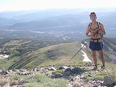
Andrew Skurka hopes to be first to walk the entire Sea-to-Sea network of hiking trails across North America.
REDMOND, Wash., Feb. 2, 2004 — Most people like to share their enthusiasm with others, and Andrew Skurka is no exception. Today, the avid long-distance trekker, 23, sets out on a 7,700-mile cross-continental trek over a network of North American hiking trails–called the “Sea-to-Sea route”–that spans from Cape Alava on the Olympic peninsula in Washington state to Cape Gaspe on the Atlantic coast in Quebec. Skurka hopes his 27-mile-a-day, nine-month journey will increase awareness of the nation’s long-distance hiking trails and inspire others to seek their own outdoor experiences.
Posting a Web log, or “blog,” of the adventure on a personal Web site might satisfy most people’s desire to share this kind of experience, but Skurka wants more. He’s intent on reaching the masses with his message, and a promising experimental research project at Microsoft is helping him do it.
The World-Wide Media eXchange (WWMX) is a set of technologies that features an online database of nearly 30,000 photos submitted by mostly amateur photographers and indexed by location. Downloadable software from the WWMX site (see Related Links, at right) can associate digital photographs containing date and time stamps with data collected from global positioning system (GPS) devices, and then link the photos to MapPoint or TerraServer maps on the WWMX site using the GPS coordinates. Colored dots scattered across a map of the world show viewers where to look for images that tell people’s stories.
Developed by the Interactive Visual Media Group at Microsoft Research, the WWMX project is focused on exploring the possibilities inherent in associating digital photographs with the location where they were shot.
Kentaro Toyama, lead research scientist on the project, and several other researchers at Microsoft came up with the idea for this project by noticing two trends: the increasing ubiquity of digital photos and the fact that more and more people, especially young adults, like and want to have records of their lives publicly available online. These two trends mean that more and more photos are going to become available online, and already the numbers are overwhelming, according to Toyama.
“We think of the WWMX as a participatory project and hope to get contributions from everyone in the world who has a digital camera,” says Toyama. “The goal is to get a huge database of photographs so that we can cover the globe with dots. That way, anyone who wants to see a photo of a particular location — say, the strait where Andy will cross the Great Lakes
Communicating Divine Inspiration — and Location
Skurka gained attention from other amateur trekkers in 2002 by walking the length of the Appalachian Trail in less than three months — about half the time it normally takes. A former National Collegiate Athletic Association Division I cross-country runner, he needed to complete the trek during the summer so that he could return to his studies at Duke University in the fall. After the success of that hike, Skurka was ready for another challenge. So when he read about the Sea-to-Sea route in an outdoor magazine last year, he immediately got hooked on the idea of hiking it.
The Sea-to-Sea route is a linkage of existing long-distance hiking trails that span almost continuously from the Pacific to the Atlantic, with the exception of several gaps, one of which is a 700-mile stretch along the Missouri River in Montana and North Dakota. Ron Strickland, who had the vision to research the links between the major trails and gave the Sea-to-Sea route its nomenclature, explored a likely path through this gap during the summer of 2003. He took pictures along the way and carried a GPS device with him. When he returned from his trek, he used WWMX software to link the location data in his GPS with his photos. In this way, he was able to share with others the possible paths by posting the geo-coded photos on the WWMX.
Skurka was inspired by Strickland’s project and plans to hike through the gap using Strickland’s proposed route. He also hopes to further Strickland’s vision by posting his own photos of the Sea-to-Sea route on the WWMX site as well.
“Indexing photographs by geographic location makes a lot of sense,” says Skurka. “It will be so much easier for people to grasp where I’ve taken a particular photograph if they can simultaneously view its location on a map, along with the names of nearby peaks and their elevations, or the up-to-date boundaries for nearby national forests and parks, as well as where that location is relative to the nearest town,” Skurka says.
Skurka estimates he’ll spend between 10 and 12 hours hiking each day. He’ll have his digital camera and a GPS device with him and plans to chronicle his route via the images he captures. Every week-and-a-half to two weeks, he’ll mail the memory cards from his digital camera and his GPS to Microsoft, where the research team will use WWMX software to associate the time and date stamp on the digital photos with the way points from his GPS data, and then post the photos on the WWMX map.
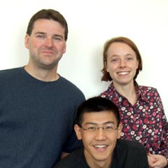
Microsoft Researchers Kentaro Toyama (front), Ron Logan, and Asta Roseway launched World-Wide Media eXchange to explore the value of associating location data with a photograph.
It’s All About Location
Why would Microsoft invest its time and resources in a research project that seems to have so little to do with the company’s bottom line? After all, Microsoft isn’t in the camera business. But according to Toyama, one of his primary responsibilities is to watch the various industries within the field of multimedia and image processing, anticipate its trends, and only then explore what value they might hold.
“Digital photography is a tidal wave right now. Digital cameras are so easy to use, and now with camera-phones, many people are carrying a camera with them all the time,” Toyama says. “We’re seeing a major shift in the way people are shooting, storing, categorizing and sharing their photos, and that shift is continuing. At Microsoft Research, we try to anticipate these changes and explore how software can support the next generation of digital shutterbugs.”
So why would people want to search for photos by location? Based on user studies, Toyama’s research team believes that people tend to intuitively categorize their photos in terms of where they were shot.
“Think about when you’re rummaging through your scrapbooks looking for a particular photo. You may not remember the year or the month you took it, but almost always, you remember the place. Location plays a really important part in intuitively categorizing the pictures we take,” Toyama says.
One of the reasons the Microsoft Research team put the WWMX online was to find out what types of people would be interested in indexing and viewing photographs in this way. Outdoor enthusiasts like Skurka and Strickland naturally gravitate toward “geo-coded” photographs because many of them use GPS devices and take lots of photos, and — perhaps more than any other type of user — they easily think of location when they categorize their shots. In addition, a lot of semi-professional and professional photographers are interested in WWMX technology simply because of the sheer numbers of photos they take and the difficulty they experience in indexing them all.
For viewers, there are many possible applications. For example, once the database is populated with enough images, viewers could use the WWMX to take a virtual tour of surrounding neighborhoods near houses they’re thinking about buying. Or they could locate and view all the photos taken at a concert they recently attended. Parents who forget to bring their cameras to a school play could later search the location and date of the play and view all the photos that other parents took of the event. And maybe, with enough photos posted on the WWMX, viewers could search the location of a particular place they were at a particular time, and see if anyone caught them on camera at that moment.
“Basically what we’re asking in our research is ‘What is the true value of associating location data with a photograph?’ Then, we explore all the different technologies that can deliver on it,” Toyama says.
The Here and Now
Toward that end, the technologies that Microsoft researchers have developed to date include a downloadable application that lets users location-stamp their photos, applications that let users view a large database of photos that have location stamps, and various technologies that make those processes easier, faster or more efficient. Toyama’s team has developed a user interface that makes it easy for users to locate the photos they’re interested in and search engines that can quickly locate images based on geography, despite the fact that the database may eventually contain millions of photos.
Right now on the WWMX, users can post any photos they’re willing to share with the rest of the world, and anyone using the downloadable WWMX application can search photos that friends and family have posted. For example, if you recently took a trip to Italy and posted the photos from the trip on the WWMX, someone using the WWMX software could enter your name, navigate to Italy on the map, and see a clickable dot for each of the photos you took. Another downloadable WWMX application that’s available now lets users create a travelogue, or slideshow, of photos using annotations that appear translucently above the images and context pop-up maps that show where each photo was taken compared to the previous one.
“The travelogue application lets users easily create something closer to a narrative or a story, rather than simply posting a batch of isolated images,” says Toyama.
The WWMX of the Future
Toyama and his colleagues hope that their project succeeds in raising the level of awareness of the value of geo-coded digital photos. In the short term, they hope to encourage software and hardware manufacturers to support the development of location-aware digital cameras. And, as the market develops and matures, they hope image databases like the WWMX become more prevalent.
“Our grandiose goal is for the WWMX is to grow a huge database of photographs to the point where it becomes a parallel World Wide Web, specifically for images,” Toyama says. “We envision it operating on the same scale as a search engine on the Internet, except that instead of typing a few words and retrieving a list of text-centric Web pages, you navigate on a map, type a few keywords, and get a host of photographs relating to your topic.”
Imagine typing the keywords “Sea-to-Sea route” on the WWMX someday soon and getting pages of results showing scores of outdoor enthusiasts’ images posted along the route. Andrew Skurka wouldn’t have it any other way.


