
REDMOND, Wash. – Dec. 2, 2009 – Bing Maps has overhauled its experience to better reflect how people are using the Web to complete tasks and make decisions. The new Bing Maps Beta adds an immersive new viewing mode and an “application gallery” to further enhance its virtual perspective of the world, Microsoft announced Wednesday.
Bing Maps now offers a Streetside and enhanced aerial view, giving users the ability to explore what’s around them from the street level or from the sky looking down.
The new Bing Maps incorporates several key Microsoft technologies, including Silverlight, a multimedia Web application, and Photosynth, an application from Microsoft Live Labs and the University of Washington that can stitch photos together, turning them into a three-dimensional model.
The new features mean Bing Maps users can now zoom in, out and around; view a location from the street level or from above; seamlessly rotate 360 degrees in one spot; view location-related content while searching an area; and even upload their own synths of a location to be integrated into a map.
Those features are largely a result of years of work done in Microsoft Research, incubation labs and product groups. “We’re in a unique position at Microsoft,” says Stefan Weitz, Bing director. “Our talent in Microsoft Research, Microsoft Live Labs and our core engineering teams really combine to be more than the sum of their parts to deliver experiences that better map to what people are doing.”
Weitz said the Bing Maps innovation is an indicator of Microsoft thinking “beyond the 10 blue links” and about what people are really trying to do with search and mapping engines.
“It’s about measuring success in the real world — not just asking the user ‘Did you find the link you were looking for?’ but rather ‘Did you accomplish what you were trying to do?’” Weitz says.
A big refresh for Bing Maps
The launch is the first big refresh of the technology behind Bing Maps in years. In addition to the new features announced this week, Bing Maps continues to acquire its own images via aerial cameras and satellites and will continually add these high-resolution images to its coverage. This focus on the quality of imagery and consistency is more expensive and time-consuming but will inevitably mean a better experience for users, Weitz says.
The new Enhanced Aerial View is a mapping mode unique to Bing that allows users to view an area from the sky using the four cardinal directions. Users can get a taste of directions “as the crow flies,” whether zooming over a high-resolution urban area or a non-urban area enhanced by satellite imagery.

“Our talent in Microsoft Research, Live Labs, and our core engineering teams really combine to be more than the sum of their parts to deliver experiences that better map to what people are doing,” says Stefan Weitz, Bing director.
The new application gallery also is exclusive to Bing Maps, and according to the Bing Community announcement, will give users the opportunity to develop “geospatially rich data visualization applications.” Users can seek out applications such as Travel Webcams and Twitter Maps, which uses Twitter’s newly released geolocation tool to map their geographic location as they tweet — even from the Streetside mode.
Streetside photography, a feature that debuted almost three years ago with Live Search Maps, now incorporates Silverlight and Photosynth technology so users can not only search for a location, but immerse themselves in it.
Streetside features 360-degree ground-level zooming and 3-D imagery, with hovering street labels so users don’t get lost, and a compass and overview map to track direction and movement.
Customization tools will also eventually allow people to help enhance Bing Maps by uploading their own images. Eventually, as users upload photos, including exterior and interior photos of locations, Bing Maps will use Photosynth to incorporate these community-generated photos so users will be able to explore the inside of locations such as restaurants, hotels or shops.
For example, Bing Maps could zoom from outer space clear down to the street outside the Metropolitan Museum of Art in New York City. Then, by enabling the Photosynth map application on the control panel, the user could go inside the museum and explore it “in amazing detail,” Weitz says.
“The number and quality of community-generated synths will continue to increase, giving amazing context and texture to geospatial searching,” he says.
Tools from Microsoft Research
Microsoft Research and the company’s scientists, engineers, and incubation labs have produced many of the tools that make the Bing Maps update possible — from the cameras used to capture the Streetside view to the technology used to stitch photos together to make a seamless panorama to the tool that allows users to zoom in, out and around.
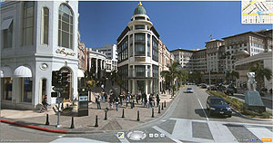
Streetside™ features 360-degree ground-level zooming and 3D imagery, with hovering street labels so users don’t get lost, and a compass and overview map to track direction and movement.
Drew Steedly, a Microsoft scientist, says Bing Maps is an ideal marriage of research and technology with product development, creating a valuable product for users.
“The number of pieces of technology in Bing Maps that have been touched by Research is amazing,” Steedly says. “It’s actually hard to think of a single piece of technology that is running in our production pipelines that wasn’t originally influenced by work in Microsoft Research.”
Steedly works in photogrammetry, the process of developing geometric properties from photographic images. He joined Microsoft in 2004, “just as online mapping was getting huge,” and has worked on Photosynth and Virtual Earth. He now is the architect for the aerial, Streetside and Photosynth processing pipelines.
Steedly says researchers at Microsoft will continue to work on ways to enhance Bing Maps, whether by looking for the most realistic and accurate ways to model the earth, streamlining how massive numbers of images used for mapping are processed, or improving the effectiveness of privacy tools that automatically blur faces and license plates.
“We’re going to take individual technologies that have been independently incorporated into our processing pipelines and unify them in a single toolbox of algorithms,” Steedly says. “We’re doing a lot of work to wrap things up and bake the technology at a higher level to make it easier for product groups to integrate.”


