
Click for high-resolution photo
REDMOND, Wash., May 22, 2002 — Ahh, its time to begin planning the family vacation — and trying to forget the unpleasant aspects of previous vacations. Piling half of your possessions and all of your kids into the car. Heading off for hours on the road in the blazing summer sun. Taking a wrong turn — too many times. Running out of gas. Living on chocolate bars, fruit juice and peanut butter crackers because you cant find a restaurant along that back road that never seems to end.
As the summer travel season kicks off, some of these scenarios will surely be unavoidable. Research group Accenture finds that 77 percent of all U.S. travelers this summer will drive at some point during their travels, an increase of 22 percent over 2001. Although driving in the car for part of the trip may be necessary, going on a trip without planning ahead or knowledge of the route, its attractions and amenities is not.
And while relying on ones wits and the ability to read maps may be one way to go, Microsoft has another option — one that allows travelers to put sophisticated technology, such as Global Positioning System (GPS) satellite data and interwoven mapping and cartographic sources, into the cars glove compartment.
Microsofts Streets & Trips 2002 software is a consumer package that loads onto virtually any desktop PC. It provides detailed and comprehensive information on routes, points of interest, restaurants and lodging, expected travel times — with gas costs incorporated, so you know how much the trip will cost — even updates on construction areas along the way. These maps can be printed, in multiple formats, directly from the desktop. Streets & Trips 2002 also includes Pocket Streets, an extension that runs on Pocket PC handheld devices. This allows travelers to carry far more information on a device that takes up less space than a stack of maps and doesnt require folding.
Online mapping tools can provide simple directions. But business or vacation travelers, or those who need to travel to multiple destinations, will find Streets & Trips a much easier, quicker and more comprehensive planning tool, says Charlie Zaragoza, a product manager for Microsofts MapPoint Business Unit.
“A lot of tools can get you from point A to point B, and the really good ones will get you back where you started,”
Zaragoza says.
“But what happens when you want to go to Points C or D? You have to go back to the Web and do the whole planning process over again. Streets & Trips allows you to easily go from A to Z — thats one of the key features that sets us apart. Youre in total control of how you get to your final destination and everywhere in between.”
The Difference Is in the Details
Streets & Trips incorporates detailed mapping of more than 6.4 million miles of local, city, state and highway roads in the United States and Canada — representing more than 35,000 US zip codes and over 700,000 Canadian postal codes. It is this detail that is important to John Slattery, who travels extensively for Powercell Corp., a manufacturer of battery-based power management systems for industries including telecommunications, government, medicine, electric utility and military facilities.
“By spending a few minutes with Streets & Trips while planning my travel, I actually save a lot of time and confusion once Im underway,”
Slattery says.
“I have used other online mapping packages too, but Streets & Trips has more versatility in terms of views and print formats that I can easily use — no matter if I am traveling across town, or across the state. Also, I find it more detailed, which really helps when I am trying to find a specific place that might be new or more out of the way.”
While paper maps and some online sources can often provide adequate large-scale directions for travel, they dont always help find the food, lodging or rest areas travelers need. Streets & Trips offers location and other information for more than 409,000 restaurants, 41,000 gas stations, 11,800 cinemas and theaters, 78,000 ATMs, 5,000 golf courses, and more — allowing travelers to locate points of interest on virtually any route, anywhere on the map.
Users can ask the program to show different options, such as the quickest route, the shortest route or the optimum route needed to visit multiple destinations. It has three map
“styles,”
showing roads, political boundaries, or terrain — or a combination of those. Streets & Trips also helps plan logistics such as suggested rest stops and how long the trip might take. After adding their normal driving speed and current cost of gas, travelers can also get a projected cost for traveling the chosen route. If a particular route is not desired or a side trip is added, travelers can drag-and-drop onto a new route, and the program will instantly recalculate the trip.
Maps on the Go — Anywhere, Anytime
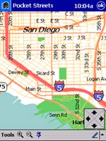
Screenshot example of the new Pocket Streets extension available with Streets & Trips 2002
Among the enhancements in Streets & Trips 2002 over previous versions is the Pocket Streets extension, which allows users to download maps — and all data related to those routes — into handheld Personal Digital Assistants (PDAs) and other devices that run on the Windows Pocket PC platform. Multiple views of maps, locations of amenities and attractions, and address searches are among the featured functions.
Slattery says he uses Pocket Streets routinely on his Casio Cassiopeia PDA.
“Like most guys, rather than stop and ask for directions when lost, I will drive until I either run out of gas or magically find my way,”
he says.
“So having this on my PDA as well as the desktop is great.”
Pocket Streets has been especially helpful when hes driving with others in an unfamiliar city.
“Streets & Trips keeps me out of trouble and makes me look a lot smarter than I would be on my own,”
he says.
Personalization is all-important when it comes to travel information, says Rob Enderle, research fellow at Giga Information Group.
“Using a handheld device makes it much more attractive — it goes with you, you can use it in any car and beyond. And a built-in system costs three times what a handheld and GPS antenna would cost,”
he says. Handheld computers can be used to create a portable equivalent of the on-board navigation systems included in many high-end cars today.
Enderle says that while the handheld device option (such as that enabled by Pocket Streets) is more cost effective now than full telematics, it may ultimately improve the market for telematics systems.
Streets & Trips 2002 supports GPS, meaning users can pinpoint their location anywhere in the United States and Canada. The built-in Web interface enables two other key functions. Users can save their route as a Web page in order to easily share travel plans with others — for a family reunion, for example. It also locates information from a Web-based database that tracks construction projects around the country, so users can learn where on their route they can anticipate construction delays.
All this data is on top of what Zaragoza calls
“the best maps available.”
He says the program incorporates cartographic data from a number of mapping sources, pulled together by what he called
“data stitching.”
“We looked at all kinds of different data vendors there was one for information within urban areas, another for information within rural regions, another for data within Canada,”
he says.
“In order to offer a best-of-breed product, we needed to pull all of these vendors together. Microsoft has a team of dedicated cartographers that blend all of these information sources together into a seamless package.”
The features and functions in Streets & Trips are not limited to the United States and Canada. European travelers get the same information in a sister product called Auto Route 2002 . It covers 2.9 million miles of streets in 11 Western European countries: United Kingdom, Germany, France, Spain, Italy, Austria, Switzerland, Denmark, Netherlands, Belgium and Luxembourg.
So, its your choice. Homestyle cooking versus stale cheese crackers, kids swimming in the hotel pool versus kids screaming in the backseat of the car, or getting to your final destination on time — and within budget — versus getting lost in nowhere land. Which sounds better?


