
Originally published in the Microsoft Research Connections Blog
Scientists around the world are striving tirelessly to monitor and model the environment—to understand the intricate workings of our ecosystem—so that policymakers can make informed decisions that lead to a sustainable future for “spaceship Earth.” This research involves using the thousands of available environmental datasets, on everything from agriculture and biodiversity to climate and the oceans. But finding, browsing, choosing, and downloading the right data can be ridiculously hard, even for the experts.
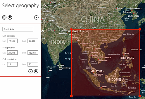
What if finding environmental data were as simple as clicking on a map?
Enter FetchClimate, a tool that makes locating environmental information as easy as searching for a hotel or coffee shop online. Just draw a box around the geographic area you’re interested in, select the environmental information you want, and view the data on Bing Maps within seconds. What used to take researchers hours, days, or even weeks can now be done very quickly—by anyone. When possible, FetchClimate calculates data uncertainty, so you know how reliable the information is, and the tool allows you to specify precisely the size of the area and the period of time for your query.
FetchClimate runs in the cloud, on Microsoft Azure, meaning there is no physical limit on how much information can be added. You can not only look at historical climate data but also peer into the future, as we have included forecast data from the latest climate simulation experiments. For example, you can see what the predicted temperature or precipitation in your area will be in 2050.
![8182_FetchClimate-as_Thumb[1]](https://news.microsoft.com/wp-content/uploads//2015/03/8182_FetchClimate-as_Thumb1.png)
The Computational Ecology and Environmental Science group in Microsoft Research has spent several years developing FetchClimate, working with Moscow State University, which provided software development, and the DigiLab at the London College of Communication, which designed an interface that makes finding and understanding environmental information stress-free. So we’re excited to be releasing FetchClimate—in three different ways—for anyone to use for research, study, or just to satisfy their curiosity about our planet.
-
First, anyone can access our own FetchClimate service via a web explorer, which features a number of useful climatological layers, including temperature, precipitation, and sea depth. (If you would like to make your information and data easily available within our service, please contact us. We are interested in augmenting our current climate and environmental data with socio-economic and health information—or any other global information best viewed on a map.)
-
Second, you can access the same service via an API, from inside a program written in any of several languages, including .NET, R, and Python.
-
And third, we’re releasing a deployment package so that the more technically savvy of you can set up your own FetchClimate-powered service to make your data available to your colleagues, and to the wider world, via the same web explorer that runs over our own service. We’ll soon be open sourcing that explorer portion of the deployment, so you can customize or skin it how you like (all we ask is that you acknowledge that the service is powered by FetchClimate).
The deployment package will be attractive to individuals, research teams, national laboratories, and international collaborations who are used to dealing with geographical data and are keen to share it with colleagues and the outside world in a more dynamic way. For example, Ireland’s Marine Institute has created the Irish Digital Ocean–SMART Marine Research Platform to stimulate collaborative research across the marine sector. As Eoin O’Grady, Information Services & Development Manager at the Marine Institute, explains, “FetchClimate greatly simplifies access to scientific data, promoting reuse. We see it as an excellent way to share Irish marine research data, part of the Irish Digital Ocean, with a broad range of users in the marine community, to support research and innovation and as input into public information services.”
In addition, we are currently sponsoring a special Climate Data Initiative that offers grants of Microsoft Azure resources to help early adopters set up their own FetchClimate-powered services. Using the deployment package, you will be able to implement your own instance of FetchClimate, including your datasets and a web front end that is customized for your own site—and we’ll provide the space on Azure! If you would like to pursue this, please submit a proposal by June 15, 2014. We will be selecting 40 awardees from among these proposals.
We created FetchClimate as a way to turn data into actionable information, and to make that information easily available to the world. There are some exciting features that we haven’t discussed here (hint: what if you could upload a model, not just data?), and FetchClimate is just one of several exciting tools for environmental science that we are developing. All of these tools illustrate how, with a bit of imagination, we can begin to deliver research-as-a-service on Microsoft Azure. We hope these tools will help scientists, policymakers, and the public become more informed and better equipped to take care of our planet.

