The story of Mont Saint Michel
Transforming a thousand-year-old city into mixed reality
![]() Esat Dedezade
Esat Dedezade
In a world where it’s possible to virtually traverse every inch of our planet from the comfort of a screen, it’s difficult to imagine a time without detailed maps.
In the 17th century, before the advent of drones, planes, or even balloons, the solution to creating accurate representations of areas was as time-consuming, as it was beautiful. Plan-relief maps (scale models of landscapes and buildings,) were hand-crafted in meticulous detail, recreating locations of interest in ways that no other means at the time could match.
Coveted by military leaders such as Napoleon and King Louis XIV, these plan-relief maps provided topographic details of landscapes, such as hills and harbours, in addition to showing off the layouts of cities and their fortifications.
In total, approximately 260 plans-relief models were created between 1668 and 1870, representing around 150 fortified sites. Today, more than 100 of these historic plan-relief maps are housed in the Musée des Plans-Reliefs in Paris, with one model in particular, drawing visitors to its beauty
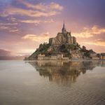
This is the story of the map of Mont-Saint-Michel—a rocky headland off the Normandy coast, with a stunning Benedictine abbey which captivates all those who step foot on the island.
Resurrecting the past
Presented by a monk to Louis XIV in 1701, the plan-relief map of Mont-Saint-Michel has survived for more than 300 years, baring the soul of the island to all those who lay eyes on it. Today, visitors to the Musée des Plans-Reliefs can do more than view the model in person, however.
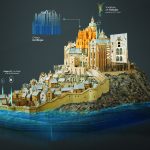
Partnering with Microsoft, HoloForge, and Iconem, a new mixed reality HoloLens experience has unlocked the secrets of the map to enable visitors to immerse themselves in a piece of French cultural history, like never before.
Thanks to thousands of painstakingly taken photos – taken by cameras on the ground and drones – a fully-recreated digital twin model of the relief map has been created, allowing visitors to experience virtual narration, annotations, descriptions and more, covering the map in 3D, from all angles.
Combining the most advanced technologies from two different worlds, centuries apart, was an ambitious feat, with incredible results. Below, you’ll find the full story of the incredible work that went into bringing Mont-Saint-Michel into the 21st Century:
The Mont Saint-Michel: Digital perspectives on the model
The Microsoft In Culture blog explores the creation of Mont Saint Michel’s virtual model, and how Iconem founder Yves Ubelmann (whose grandfather was an architect who worked on restoring Mont-Saint-Michel,) believes this kind of preservation is critical to helping future generations experience and connect with important pieces of our history and heritage.
The Musée des Plans-Reliefs in Paris partnered with Microsoft to transform their 3D relief map of Mont-Saint-Michel. The hybrid experience unlocks new ways for visitors to interact with the rare artifact. Echoing the relief map’s past impact, this exhibit lets visitors celebrate, explore, and be a part of preserving history in an unprecedented way.
The art behind Napoleon and Louis XIV’s 3-D maps
In this three-part Today in Technology series, Microsoft President Brad Smith and Communications Director Carol Ann Browne examine how AI and mixed reality can open a new window into French culture by using technology like HoloLens. Their journey to help the Musée des Plans-Reliefs adapt its historical 3-D map collection for a digital audience sheds new light on the story of Mont-Saint-Michel, off the coast of Normandy, France, that has captured imaginations for centuries. First, they go to Paris where the once-secret military maps of Louis XIV and Napoleon have been on display for decades. Can HoloLens technology help transform these treasures for audiences in the 21st century?
How developers used new technology to transform iconic French maps
Go on a journey to Mont-Saint-Michel in Normandy, France, with Microsoft President Brad Smith and Communications Director Carol Ann Browne as they talk to Iconem and HoloForge about the possibilities AI and mixed reality bring to preserving culture. In this three-part Today in Technology series, they examine how AI and mixed reality can open a new window into French culture by using technology like HoloLens.
What Mont-Saint-Michel looks like through HoloLens
See the results of a months-long effort to create a HoloLens experience that pays homage to Mont-Saint-Michel, in Normandy, France, in all its forms – as a physical relief map and work of art; as a real place visited by millions of people over the centuries; and as a remarkable digital story of resilience. In this three-part Today in Technology series, they examine how AI and mixed reality can open a new window into French culture by using technology like HoloLens.