How AI is helping map the world’s most vulnerable places
In December 2013, a boy was playing in the hollow of a tree near his home in Meliandou, a remote village in the West African country of Guinea. The tree was home to a colony of bats that carried a virus – Ebola.
Within days, the boy had died, the first victim of an outbreak that spread to neighboring countries and beyond, into Europe and the United States. Over the next two-and-a-half years, more than 28,600 cases of Ebola were reported, with 11,325 of those fatal.
Rapid-onset cases such as this put vulnerable communities at risk because aid agencies and authorities don’t have the data they require.
“If a patient is admitted to a medical facility and is found to have Ebola, public health workers and clinicians need to know who else that person may have come into contact with,” says Tyler Radford, executive director of the Humanitarian OpenStreetMap Team (HOT). “That’s their best hope for catching the illness early enough to arrest the spread of the disease and help anyone who has caught it.”
But how can you track a patient’s movements if the maps you are using are not adequate? Not being able to find villages and settlements; not knowing where roads lead; and not being able to say with certainty where people may have encountered infected individuals hampered aid efforts.
“Was that sick person on a bus?” Radford continues. “Where did the bus come from and where were the other passengers going?”
[READ MORE: How AI can help save lives in emergencies]
The big picture
Although there are very few completely unmapped parts of the world, not all places have been mapped in the same level of detail. Across North America, Europe and most of the developed world, there is no shortage of data added to maps and mapping systems. Roads, houses, schools, hospitals, businesses and more are drawn, labelled – even photographed – and made searchable.
By contrast, that is often not that case with the remotest parts of some countries.
The need for accurate data is what drives HOT’s work.
This non-profit organization is working with Microsoft’s AI for Humanitarian Action program and Bing to bring together satellite mapping, machine learning and an army of volunteers to create a new generation of detailed and potentially life-saving maps.
People and machines working together
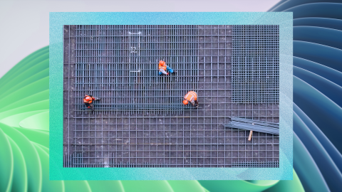
Those who would like to help can sign up for an account on the HOT Missing Maps site. They can search a satellite image of an area and mark up what look like buildings, adding an extra layer of data and increasing the levels of detail to OpenStreetMap. Now that work is being augmented by technology.
Working with Microsoft has made it possible for HOT to develop AI-powered tools that will make the work of the human volunteer force more impactful. “The AI is not a replacement for the work our teams of people do,” Radford points out.
“It can predict features, suggest that a shape may be a building and it speed up that initial identification. That way our people can bring the value they add faster, too, determining what a feature is, adding detailed information.”
READ MORE: How AI is helping unlock information about melting glaciers]
Making progress
Mapping some of Africa’s most remote communities is a priority for HOT. Collaborating with Microsoft’s Bing Maps, HOT set out first to map Uganda and Tanzania. Eventually, it hopes to map the whole of the continent.
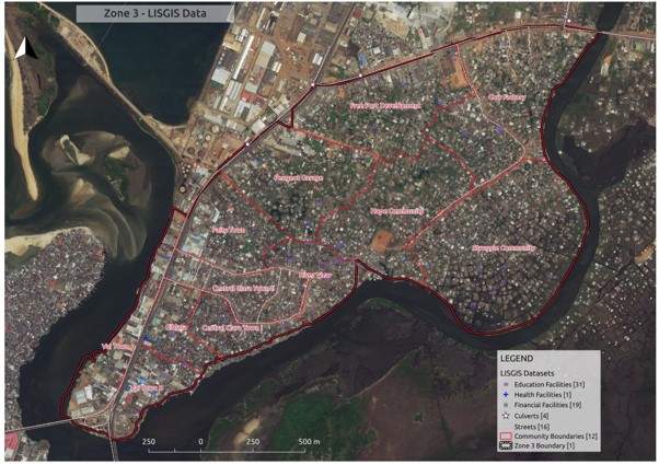
Satellite imagery of Monrovia, Liberia, with map data overlaid. Photograph: Humanitarian OpenStreetMap Team/LISGIS Datasets; (top) field mapping in Mvepi, Uganda. Photograph: Humanitarian OpenStreetMap Team
HOT has almost completed a detailed map of the Tanzanian coastal city of Dar es Salaam, which is one of the fastest growing in Africa. It is vulnerable to several climate change effects, including flooding. It also has inconsistent construction standards. The new maps show the conditions of roads, buildings and other key infrastructure.
The benefits can also be seen in more remote parts of Tanzania, such as the Sepuka region in the central part of the country. Its population of around 24,000 is dispersed across a wide area, but it’s now possible to zoom in via OpenStreetMap and see individual buildings.
[READ MORE: How AI and satellites are used to combat illegal fishing]

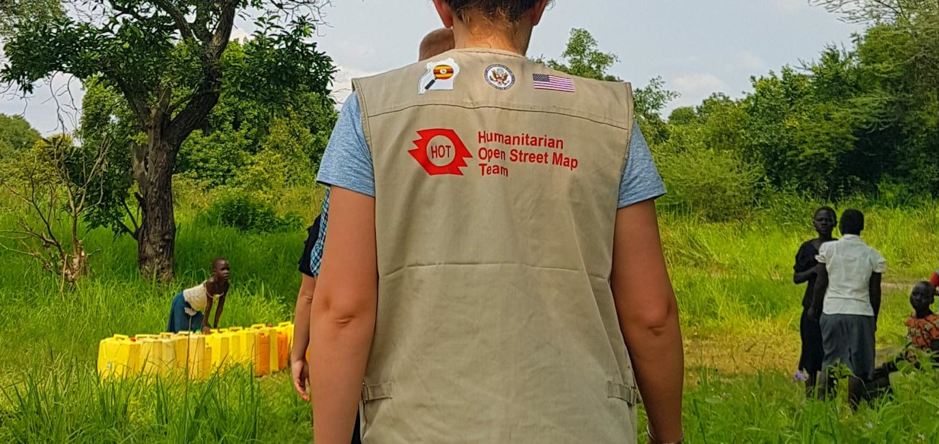
A HOT ‘mapathon’ in Indonesia. Photograph: Humanitarian OpenStreetMap Team
During an emergency, that level of detail is crucial. Making the right decisions quickly is contingent on having the best information to hand. Without reliable data, no analysis of a situation will be complete. Knowing what action to take and where to direct resources can be the difference between success and failure.
When disaster strikes
The importance of accurate data was clearly shown in April 2015, when a Level VIII (or “severe”) earthquake, one of the worst of the modern era, struck the mountainous country of Nepal. As many as 9,000 people lost their lives, and around 600,000 homes were destroyed.
Reaching the worst-affected areas was a challenge for rescue teams. The Himalayas are stunning but can also be inhospitable, even more so when seismic activity causes landslides, rockfalls and the collapse of roads. Simply knowing where to direct efforts was an issue the rescue operation urgently needed to address.
Within a matter of hours, HOT had sprung into action. Soon volunteers and partner agencies from all over the world were working together and coordinating with observers on the ground to build detailed maps of the affected area. They identified damaged roads and residential neighborhoods, located camps of displaced people, and found open spaces for helicopter landing zones. In total, more than 4,000 mappers took part in the disaster response.
The combination of on-the-ground knowledge and committed volunteers with powerful AI and huge datasets has enormous potential. In the wake of a disaster, it can be the difference between life and death.
For more on how technology can save lives, visit AI for Humanitarian Action. And follow @MSFTIssues on Twitter.